
AerialAccess
| Dutchess County NY
search
Explore the map on your own or select places of interest from the list on the right.
compareCompare imagery from different time periods using the slider bar.
arrow_drop_down_circleChange imagery using the dropdown menus at the top of the map.
Turf
Unlike vegetation, artificial material such as astroturf absorbs large amounts of infrared light. Slide over the track and watch how the field does not change.
Bannerman Castle
The ruins of Bannerman Castle continue to fall into disrepair. Coupled with a steady rise in sea level, Pollepel Island and the old ruins are rapidly disappearing.
Quarry
The site of Dutchess Quarry & Supply Co. Inc. has expanded steadily over the last century. It now operates as a subsidiary of Peckham Industries, Inc.
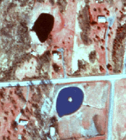
DeFlora Brothers Dam
Building of the DeFlora Brothers Dam formed what is now called Apple Lake. Use the slider to show the the area before and after the dam was constructed.
Dutchess County Airport
Since its construction in the 1930s, the Dutchess County Airport has gone through several changes. Most noticeably, the main runway was lengthened to 5,001 (ft) to accommodate larger aircraft.
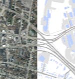
Kingston-Rhinecliff Bridge
Construction began on the "continuous under-deck truss" style bridge in the mid 1950s, replacing the sporadic and often unreliable ferry service.
Shadows
Shadows are often an unwanted side-affect in aerial photography, primarily because they make land classification more difficult. However, using more advanced photo-interpretation techniques it is possible to calculate time of day and even the height of structures using the size and position of shadows.
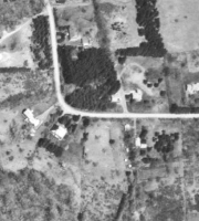
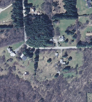
Suburban Growth
As veterans returned home from World War II, they settled into suburban areas to start families. During the 1950s, you can see rapid development and expansion of the suburbs and the subsequent beginning of the "baby boom." Use the slider to show the suburban expansion of Hyde Park.
Mosaics
Orthophotography
Resolution
Black and White (BW)
True Color (TC)
Color Infrared (CIR)
National Agriculture
Imagery Program (NAIP)
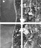

Mosaics consist of a series of overlapping aerial photos that have been geographically aligned with ground control points. This process of "rectifying" the images sometimes involves rotating, stretching and combining images so that they planimetrically match the area that they cover.
An orthophotograph, or "orthoimage", is an aerial photo that has been geometrically corrected so that the scale across it is uniform. This process combines the planimetric precision of a map with the detail available in an aerial photograph. Accurate measurements of distance, area and directions can be made. However the resolution of the aerial photograph needs to be accounted when considering the precision of any measurement.
The resolution of aerial photography is generally expressed as the amount of area covered by one pixel. For example, imagery with a "one foot pixel" resolution will cover one foot of ground in each pixel. Each flight year displays their resolution in the bottom-left and bottom-right corners of the map.
Imagery prior to the year 2000 does not contain precise resolution, since the imagery was taken with analog cameras, which do not result in pixels until digitized.
Black and White (BW) aerial photography has been in use since the 1930's, and was the standard for all aerial photography in Dutchess County until the transition to digital cameras in the mid-1990's. All of the black and white flight years were digitized and rectified from archival material in the 2010's.
True Color (TC) imagery shows the natural color of the landscape - it shows what your eyes would see from a plane flying over Dutchess County. Digital true color imagery is captured in three bands of color: red, green and blue, which are then projected onto the map's pixel color values.
True color tends to be our "default" aerial type, since it is what your eyes expect to see. True color is also the best for seeing underwater features.
In "true color" imagery, the color values of red, green and blue correspond to the red, green and blue light wavelengths captured by the digital camera. In Color Infrared (CIR) imagery, the red, green and blue instead correspond to near-infrared light, red light and green light.
This process results imagery that looks weirdly colored, but is useful in detecting things that the eye cannot see. For instance, healthy vegetation, which emits invisible infrared light, will appear as red in CIR imagery. Similarly, due to the shift of green to blue, and the exclusion of blue entirely, CIR imagery is superior for mapping wetland boundaries and detecting the water clarity of ponds and lakes.
The flight years marked NAIP are true orthoimagery from the National Agriculture Imagery Program, a program organized by the US Deptartment of Agriculture.
The NAIP imagery tends to be "leaf-on" imagery (imagery taken while deciduous trees still have their leaves) because their flights coincide with the agricultural growing season. By contrast, Dutchess County typically acquires orthoimagery during "leaf-off" periods for a greater accuracy of properties and ulilities.
Click to Learn More.
Toggle the reference layers on and off by clicking on the boxes below. Please note that some reference layers are scale dependent and will not appear if you are zoomed out too far.

Icons indicating points of interest throughout the county. Includes parks, schools, emergency response stations, healthcare locations and public services.
1:32,000
Roads and road labels representing current-day roads. Historical roads are not recorded.
1:16,000
Current tentative or final roll parcel lines. For reference only. Boundaries may not align with historical aerials and do not depict historical property boundaries.
For more information about parcels, visit Dutchess County ParcelAccess.
1:32,000
Boundary lines of the current-day Dutchess County towns, villages and cities. Historical boundaries are not represented.
1:500,000